Hurricane Blizzard 2014 Part Deux!!
Hoth In Orchard Park
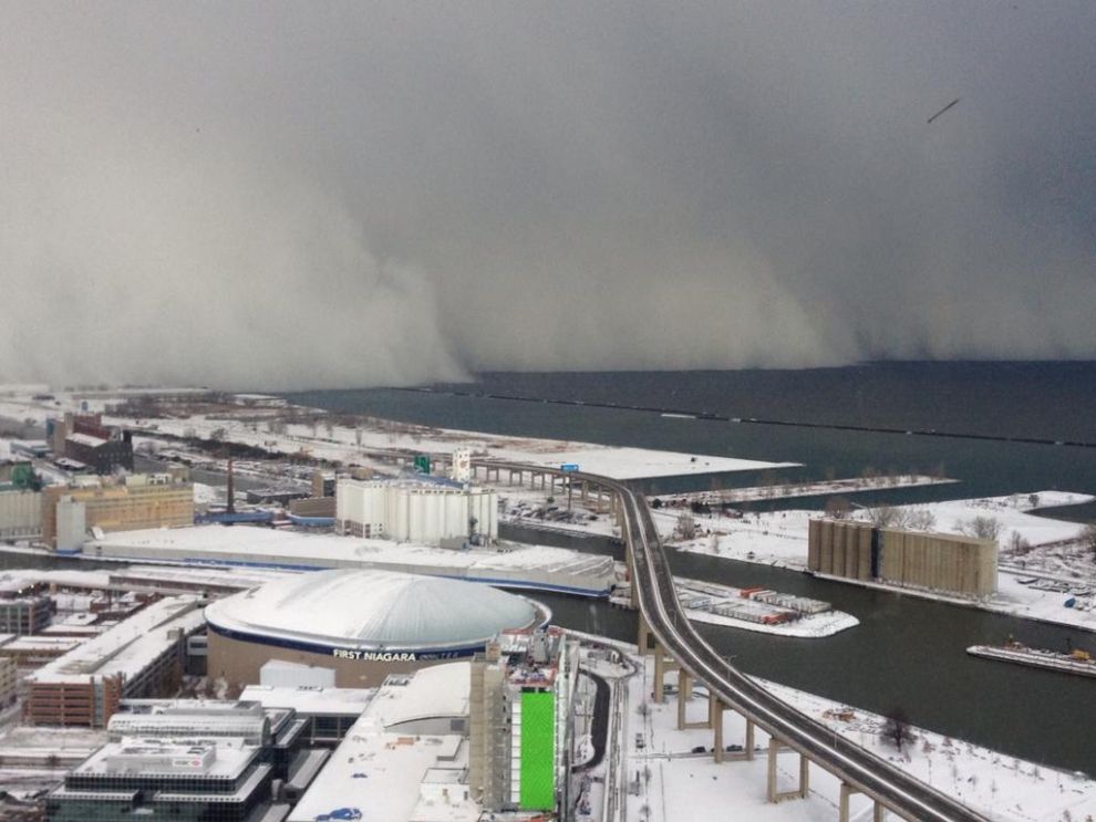
Click To Enlarge - Nov 18th - WOW!!
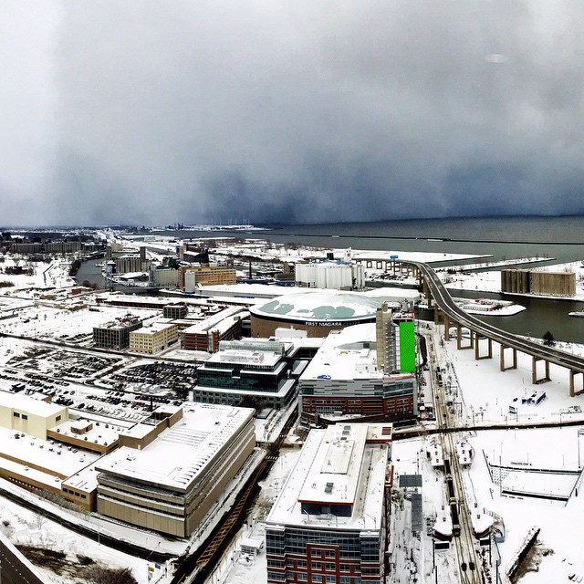
Click To Enlarge - Nov 20th - WOW!!
Let Your Friends Know About Hurricane Blizzard 2014 Part Deux! |
Record Report - Statement as of 4:37 am EST on November 20, 2014
...Record daily maximum snowfall set at Buffalo NY...
A record snowfall of 76 inches was set at Buffalo NY yesterday. This breaks the old record of 58 set in 2000 ![]()
Instagram accounts greenguy89, kiki5380, and mejiaheather from Orchard Park, NY (Official Total: 63" or 1.6m)
Random Stuff...
Digging Out!
Front & Backyard Update, Icicle Time!
Front & Backyard Update Vids & Official 3" Stick Update
I keep having to dig out my yardstick. Tues 3 PM, Wed 1 PM, Thu Noon and 6 PM.
It's 2' above the yardstick (that's a total of 1.63 meters for you metric geeks)
Had to go out, so took some comparison pics...
Had to make sure the backup generator wasn't covered...and snow hijinx!
As much as I don't want to start another keyword frenzy, I bring to you Thunder Snow!
...and so it begins...again!
Various Shots Around The House
Backyard & The Sun?!
Front Porch/Yard
27" So Far
Front Porch/Yard
The Return Of The Hurricane Blizzard!!
Instagram Pics From Friends:
Stay tuned for more pics/vids of SNOW!!
Weather Alerts, Warnings, and Information from Weather Underground
Area Flood Watch
Statement as of 11:59 AM EST on November 21, 2014
...Flood Watch remains in effect from Sunday afternoon through Wednesday morning...
The Flood Watch continues for
* a portion of western New York...including the following counties...Genesee...northern Erie...southern Erie and Wyoming.
* From Sunday afternoon through Wednesday morning.
* Snow melt from the recent significant lake effect snow events combined with rainfall early next week will bring the potential for significant flooding.
* Smaller streams and creeks will be prone to flooding from snow melt. This will include the creeks that flow through the Buffalo Metro area...including Cayuga...Buffalo...Cazenovia an Ellicott creeks. Towns that received significant amounts of snow will also have potential for urban flooding from the snow melt.
Precautionary/preparedness actions...
A Flood Watch means there is a potential for flooding based on current forecasts. You should monitor later forecasts and be alert for possible flood warnings. Those living in areas prone to flooding should be prepared to take action should flooding develop. Stay tuned to weather radio or other radio and TV stations for further details or updates
Public Information Statement
Statement as of 11:58 am EST on November 21, 2014
The following are week long snow totals from Monday evening through Friday morning. This includes both rounds of heavy lake effect snow that impacted the region.
********************Storm total snowfall********************
Location storm total time/date comments snowfall of /inches/ measurement
New York
...Chautauqua County... 1 WNW Fredonia 22.7 1100 am 11/21 cocorahs 4 SSW Ripley 10.4 1100 am 11/21 cocorahs Kennedy 7.0 1100 am 11/21 cocorahs
...Erie County... Lancaster 74.0 1100 am 11/21 NWS employee Wales Center 69.3 1100 am 11/21 cocorahs 2 NNE Orchard Park 63.0 1100 am 11/21 NWS employee 2 SSW Blasdell 61.0 1100 am 11/21 cocorahs 4 NW Alden 57.5 1100 am 11/21 cocorahs West Seneca 55.5 1100 am 11/21 cocorahs Colden 55.1 1100 am 11/21 coop observer 2 NE Boston 48.0 1100 am 11/21 cocorahs Akron 26.7 1100 am 11/21 cocorahs 2 se Glenwood 26.3 1100 am 11/21 cocorahs NY Buffalo Intl Arpt 16.9 1100 am 11/21 ASOS 3 ESE Tonawanda 7.9 1100 am 11/21 cocorahs Kenmore 6.8 1100 am 11/21 cocorahs 1 N Clarence Center 5.5 1100 am 11/21 cocorahs
...Genesee County... Corfu 49.0 1100 am 11/21 amateur radio Stafford 17.7 1100 am 11/21 cocorahs
...Jefferson County... Carthage 33.4 1100 am 11/21 cocorahs Theresa 27.5 1100 am 11/21 cocorahs Watertown 24.7 1100 am 11/21 cocorahs
...Lewis County... highmarket 28.6 1100 am 11/21 coop observer 5 SSW Harrisville 27.8 1100 am 11/21 cocorahs 1 NW Constableville 27.5 1100 am 11/21 cocorahs Beaver Falls 18.5 1100 am 11/21 cocorahs Glenfield 9.3 1100 am 11/21 coop observer
...Monroe County... Rochester Intl Arpt 9.3 1100 am 11/21 ASOS
...Niagara County... 5 NNE Amherst 8.5 1100 am 11/21 cocorahs 1 NNE north tonawand 4.9 1100 am 11/21 cocorahs 1 NE Lockport 4.6 1100 am 11/21 cocorahs Niagara Falls 4.6 1100 am 11/21 coop observer Youngstown 3.7 1100 am 11/21 coop observer
...Oswego County... 8 NNW Redfield 29.0 1100 am 11/21 cocorahs 5 ESE Oswego 13.1 1100 am 11/21 cocorahs Bennetts bridge 9.0 1100 am 11/21 coop observer Minetto 5.0 1100 am 11/21 cocorahs Palermo 2.0 1100 am 11/21 coop observer
...Wyoming County... Cowlesville 88.0 1100 am 11/21 amateur radio Wyoming 63.0 1100 am 11/21 coop observer Warsaw 28.8 1100 am 11/21 coop observer
Area Flood Watch
Statement as of 6:29 AM EST on November 21, 2014
...Flood Watch remains in effect from Sunday afternoon through Wednesday morning...
The Flood Watch continues for
* a portion of western New York...including the following counties...Genesee...northern Erie...southern Erie and Wyoming.
* From Sunday afternoon through Wednesday morning.
* Snow melt from the recent significant lake effect snow events combined with rainfall early next week will bring the potential for significant flooding.
* Smaller streams and creeks will be prone to flooding from snow melt. This will include the creeks that flow through the Buffalo Metro area...including Cayuga...Buffalo...Cazenovia an Ellicott creeks. Towns that received significant amounts of snow will also have potential for urban flooding from the snow melt.
Precautionary/preparedness actions...
A Flood Watch means there is a potential for flooding based on current forecasts. You should monitor later forecasts and be alert for possible flood warnings. Those living in areas prone to flooding should be prepared to take action should flooding develop. Stay tuned to weather radio or other radio and TV stations for further details or updates
Lake Effect Snow Warning
Statement as of 3:00 PM EST on November 20, 2014
...Lake effect snow warning remains in effect until 1 am EST Friday...
* locations...Erie...Genesee...and Wyoming counties. This includes the Buffalo Metro area. The band will remain stationary through about 6pm then move south through the evening.
* Timing...through 1 am Friday.
* Accumulations...snowfall rates of 3 to 5 inches per hour in the most intense portion of the band. Storm totals of 3 to 4 feet from Angola across the Boston Hills to East Aurora...northern Wyoming County and southwest Genesee County with 1 to 2 feet north and south of that corridor.
* Winds...west 15 to 25 mph with gusts to 35 mph producing significant blowing and drifting snow.
* Visibilities...near zero at times.
* Impacts...heavy lake effect snow will result in very difficult or nearly impossible travel at times in the heaviest portion of the band. Thunder and lightning will accompany the heaviest snow. If you must travel during the lake effect snow...expect severe winter driving conditions with very low visibility and deep snow cover on roads. Some roads that have been cleared may become impassable again. Do not travel in the most heavily affected areas! Snow loads on buildings may reach critical levels and result in structural failure.
Precautionary/preparedness actions...
If you lose power and plan on running a generator...make sure that the generator is located outdoors and is properly ventilated. Space heaters should also be properly ventilated and used only if they are operating properly. Make sure snow does not block exhausts and fresh air intakes for high efficiency furnaces and water heaters.
Stay tuned to NOAA Weather Radio or your favorite source of weather information for the latest updates. Additional details can also be found at www.Weather.Gov/Buffalo.Report snow accumulation to the National Weather Service in Buffalo by sending an email to bufstorm.Report@noaa.Gov...posting to the NWS Buffalo facebook Page...or tweet...using the hashtag bufwx
Lake Effect Snow Warning
Statement as of 9:30 AM EST on November 20, 2014
...Lake effect snow warning remains in effect until 1 am EST Friday...
* locations...Erie...Genesee...and Wyoming counties. This includes the Buffalo Metro area. The band is expected to drift back north over the immediate Buffalo southtowns east to Batavia during the afternoon before moving south again this evening.
* Timing...through overnight tonight.
* Accumulations...storm total accumulations of 2 to 3 feet in the most persistent bands. Greatest accumulations expected from Angola across the Boston Hills to East Aurora and western Wyoming County.
* Winds...west 15 to 25 mph with gusts up to 35 mph producing blowing and drifting snow.
* Visibilities...near zero at times.
* Impacts...heavy lake effect snow will result in very difficult or nearly impossible travel at times in the heaviest portion of the band. Thunder and lightning will accompany the heaviest snow. If you must travel during the lake effect snow...expect severe winter driving conditions with very low visibility and deep snow cover on roads. Some roads that have been cleared may become impassable again. Do not travel in the most heavily affected areas! Snow loads on buildings may reach critical levels and result in structural failure.
Precautionary/preparedness actions...
If you lose power and plan on running a generator...make sure that the generator is located outdoors and is properly ventilated. Space heaters should also be properly ventilated and used only if they are operating properly. Make sure snow does not block exhausts and fresh air intakes for high efficiency furnaces and water heaters.
Stay tuned to NOAA Weather Radio or your favorite source of weather information for the latest updates. Additional details can also be found at www.Weather.Gov/Buffalo.Report snow accumulation to the National Weather Service in Buffalo by sending an email to bufstorm.Report@noaa.Gov...posting to the NWS Buffalo facebook Page...or tweet...using the hashtag bufwx
Lake Effect Snow Warning
Statement as of 8:54 PM EST on November 19, 2014
...Lake effect snow warning remains in effect until 1 am EST Friday...
* locations...Erie...Genesee...and Wyoming counties. This includes the Buffalo Metro area. Greatest accumulations expected from South Buffalo to the nearby southern and eastern suburbs extending into the southwest corner of Genesee County and the northwest corner of Wyoming counties.
* Timing...late this evening through overnight Thursday night.
* Accumulations...5 to 8 inches overnight...more than 2 feet Thursday...and 5 to 10 inches Thursday night...leading to storm totals of 2 to 3 feet in the most persistent lake snows.
* Winds...west 15 to 25 mph.
* Visibilities...a couple hundred feet at times.
* Impacts...heavy lake effect snow will result in very difficult or nearly impossible travel at times in the heaviest portion of the band. Thunder and lightning will accompany the heaviest snow. If you must travel during the lake effect snow...expect severe winter driving conditions with very low visibility and deep snow cover on roads. Some roads that have been cleared may become impassable again. Do not travel in the most heavily affected areas! Snow loads on buildings may reach critical levels and result in structural failure.
Precautionary/preparedness actions...
If you lose power and plan on running a generator...make sure that the generator is located outdoors and is properly ventilated. Space heaters should also be properly ventilated and used only if they are operating properly. Make sure snow does not block exhausts and fresh air intakes for high efficiency furnaces and water heaters.
Stay tuned to NOAA Weather Radio or your favorite source of weather information for the latest updates. Additional details can also be found at www.Weather.Gov/Buffalo.Report snow accumulation to the National Weather Service in Buffalo by sending an email to bufstorm.Report@noaa.Gov...posting to the NWS Buffalo facebook Page...or tweet...using the hashtag bufwx
Lake Effect Snow Warning
Statement as of 12:28 PM EST on November 19, 2014
...Lake effect snow warning remains in effect from 11 PM this evening to 1 am EST Friday...
* locations...Erie County including the Buffalo Metro area.
* Timing...late this evening through Thursday night.
* Accumulations...additional accumulations of around 2 feet in the most persistent snows. The heaviest amounts may again focus on areas from South Buffalo to the nearby southern and eastern suburbs.
* Winds...southwest 20 to 30 mph with gusts to 40 mph producing significant blowing and drifting snow.
* Visibilities...near zero at times.
* Impacts...heavy lake effect snow will result in very difficult or nearly impossible travel at times in the heaviest portion of the band. If you must travel during the lake effect snow... expect severe winter driving conditions with very low visibility and deep snow cover on roads. Some roads that have been cleared may become impassable again. Snow loads on buildings may reach critical levels and result in structural failure.
Precautionary/preparedness actions...
If you lose power and plan on running a generator...make sure that the generator is located outdoors and is properly ventilated. Space heaters should also be properly ventilated and used only if they are operating properly. Make sure snow does not block exhausts and fresh air intakes for high efficiency furnaces and water heaters.
Stay tuned to NOAA Weather Radio or your favorite source of weather information for the latest updates. Additional details can also be found at www.Weather.Gov/Buffalo.Report snow accumulation to the National Weather Service in Buffalo by sending an email to bufstorm.Report@noaa.Gov...posting to the NWS Buffalo facebook Page...or tweet...using the hashtag bufwx
Special Statement
Statement as of 12:39 PM EST on November 19, 2014
...Extreme snow safety concerns...
Moving all this snow can be dangerous. Here are some precautions.
* Do not overexert yourself...shoveling or even walking in the heavy snow is extremely taxing. Take plenty of breaks to avoid overexerting yourself.
* Overstressed roofs can collapse. Snow removal off structures is a dangerous activity that should only be done by qualified individuals following safety protocols to minimize risks. If at any time there is a concern that snow loads may cause a collapse...evacuate the building. Signs of overstressed roofs may include sagging tiles or boards. Popping...cracking...or creaking sounds also signal significant danger.
* Travel safety...many roads are still in extremely poor condition or are impassible. Heed local...regional and other emergency travel bans. Take the time now and place a winter safety kit in your car. Items include but are not limited to...a fully charged cell phone...blankets...flashlight...knife...non-perishable food...clothing...and a shovel.
* Clear snow from high efficiency furnace pipes...snow covering furnace pipes can lead to Carbon monoxide build up in your home. Ensure Carbon monoxide detectors have fresh batteries and are working properly.
* Generator safety...if you are relying on a generator for power make sure the generator is located away from the house and not in an enclosed space. Running a generator indoors can lead to a build of harmful gases in your home.
* Space heater safety...space heaters should also be properly ventilated and used only if they are operating properly.
Lake Effect Snow Warning
Statement as of 6:34 AM EST on November 19, 2014...Lake effect snow warning remains in effect until 1 PM EST this afternoon... ...Lake effect snow warning remains in effect from 11 PM this evening to 1 am EST Friday...
* locations...Erie County including the Buffalo Metro area.
* Timing...first warning continues through midday today. The second warning late tonight through Thursday night.
* Accumulations...3 to 8 inches today.
Additional accumulations of up to 2 feet late tonight through Thursday night in persistent bands. The heaviest amounts may again focus on the Buffalo southtowns.
* Visibilities...as low as a quarter mile at times.
* Impacts...intense lake effect snow and blowing snow will result in very difficult or nearly impossible travel at times within the most intense portion of the band. Expect widespread Road closures. Travel will be impossible within the most intense portion of the band. If you must travel be prepared for severe winter driving conditions with near zero visibility and deep snow cover on roads. This includes the New York state thruway from Silver Creek to Batavia.
Precautionary/preparedness actions...
In lake effect snow the weather can vary from locally heavy snow in narrow bands to clear skies just a few miles away. If you will be traveling across the region be prepared for rapid changes in Road and visibility conditions.
If you lose power and plan on running a generator...make sure that the generator is located outdoors and is properly ventilated. Space heaters should also be properly ventilated and used only if they are operating properly. Make sure snow does not block exhausts and fresh air intakes for high efficiency furnaces and water heaters.
Stay tuned to NOAA Weather Radio or your favorite source of weather information for the latest updates. Additional details can also be found at www.Weather.Gov/Buffalo.
Report snow accumulation to the National Weather Service in Buffalo by sending an email to bufstorm.Report@noaa.Gov...posting to the NWS Buffalo facebook Page...or tweet...using the hashtag bufwx
Lake Effect Snow Warning
Statement as of 3:33 PM EST on November 18, 2014...Lake effect snow warning remains in effect until 1 PM EST Wednesday... ...Lake effect snow warning in effect from 11 PM Wednesday to 1 am EST Friday...
The National Weather Service in Buffalo has issued a lake effect snow warning...which is in effect from 11 PM Wednesday to 1 am EST Friday.
* Locations...Erie...Genesee...and Wyoming counties including the Buffalo Metro area. Northern extent of the snow band along a line from South Buffalo to Depew and Batavia through this evening.
* Timing...first warning continues through midday Wednesday. The second warning runs from late Wednesday evening through Thursday night.
* Accumulations...snowfall rates of 2 to 4 inches per hour in the most intense portion of the band. Storm totals will reach 3 to 4 feet in many areas along and south of a line from South Buffalo to Batavia. Local amounts of 5 to 6 feet from Lackawanna to Lancaster and Elma from the first storm ending on Wednesday.
Additional accumulations of up to 2 feet in the second storm late Wednesday night through Thursday night in persistent bands. The heaviest amounts may again focus on the Buffalo southtowns.
* Winds...southwest 20 to 25 mph with gusts up to 40 mph producing localized blizzard conditions at times with significant blowing and drifting snow.
* Visibilities...near zero at times.
* Impacts...intense lake effect snow and blowing snow will result in very difficult or nearly impossible travel at times within the most intense portion of the band. Expect widespread Road closures. Travel will be impossible within the most intense portion of the band. If you must travel be prepared for severe winter driving conditions with near zero visibility and deep snow cover on roads. This includes the New York state thruway from Silver Creek to Batavia.
Precautionary/preparedness actions...
In lake effect snow the weather can vary from locally heavy snow in narrow bands to clear skies just a few miles away. If you will be traveling across the region be prepared for rapid changes in Road and visibility conditions.
If you lose power and plan on running a generator...make sure that the generator is located outdoors and is properly ventilated. Space heaters should also be properly ventilated and used only if they are operating properly. Make sure snow does not block exhausts and fresh air intakes for high efficiency furnaces and water heaters.
Stay tuned to NOAA Weather Radio or your favorite source of weather information for the latest updates. Additional details can also be found at www.Weather.Gov/Buffalo.
Report snow accumulation to the National Weather Service in Buffalo by sending an email to bufstorm.Report@noaa.Gov...posting to the NWS Buffalo facebook Page...or tweet...using the hashtag bufwx
Lake Effect Snow Warning, Lake Effect Snow Watch
Statement as of 9:39 AM EST on November 18, 2014...Lake effect snow warning remains in effect until 1 PM EST Wednesday... ...Lake effect snow watch remains in effect from late Wednesday night through late Thursday night...
* locations...Erie...Genesee...and Wyoming counties including the Buffalo Metro area. Northern extent of the snow band from roughly a line from downtown Buffalo to Depew and Batavia.
* Timing...warning through midday Wednesday. Watch from late Wednesday night through late Thursday night.
* Accumulations...snowfall rates of 3 to 5 inches per hour in the most intense portion of the band. This will bring storm totals to 5 to 6 feet in the most persistent snows.
* Winds...southwest 20 to 30 mph with gusts to 40 mph producing localized blizzard conditions at times with significant blowing and drifting snow.
* Visibilities...near zero at times.
* Impacts...intense lake effect snow and blowing snow will result in very difficult or nearly impossible travel at times within the most intense portion of the band. Expect widespread Road closures. Travel will be impossible within the band. If you must travel be prepared for severe winter driving conditions with near zero visibility and deep snow cover on roads. This includes the New York state thruway from Silver Creek to Batavia.
Precautionary/preparedness actions...
In lake effect snow the weather can vary from locally heavy snow in narrow bands to clear skies just a few miles away. If you will be traveling across the region be prepared for rapid changes in Road and visibility conditions.
If you lose power and plan on running a generator...make sure that the generator is located outdoors and is properly ventilated. Space heaters should also be properly ventilated and used only if they are operating properly. Make sure snow does not block exhausts and fresh air intakes for high efficiency furnaces and water heaters.
Stay tuned to NOAA Weather Radio or your favorite source of weather information for the latest updates. Additional details can also be found at www.Weather.Gov/Buffalo.
Report snow accumulation to the National Weather Service in Buffalo by sending an email to bufstorm.Report@noaa.Gov...posting to the NWS Buffalo facebook Page...or tweet...using the hashtag bufwx
Lake Effect Snow Warning, Lake Effect Snow Watch
Statement as of 6:52 AM EST on November 18, 2014...Lake effect snow warning remains in effect until 1 PM EST Wednesday... ...Lake effect snow watch remains in effect from late Wednesday night through late Thursday night...
* locations...Erie...Genesee...and Wyoming counties including the Buffalo Metro area. Northern extent of the snow band from roughly a line from Buffalo to the Buffalo Airport to Batavia.
* Timing...lake effect snow warning continues through midday Wednesday. Lake effect snow watch late Wednesday night through late Thursday night.
* Accumulations...snowfall rates of 3 to 5 inches per hour in the most intense portion of the band. Snow accumulating 3 to 4 feet in the most persistent bands. Additional significant amounts possible late Wednesday night through late Thursday night.
* Winds...southwest 20 to 30 mph with gusts up to 45 mph producing localized blizzard conditions at times with significant blowing and drifting snow.
* Visibilities...as low as a quarter mile at times.
* Impacts...intense lake effect snow and blowing snow will result in very difficult or nearly impossible travel at times within the most intense portion of the band. Expect Road closures or snow covered roads that are nearly impassable within the snow band. If you must travel be prepared for severe winter driving conditions with near zero visibility and deep snow cover on roads. This includes the New York state thruway from Silver Creek to Batavia.
Precautionary/preparedness actions...
In lake effect snow the weather can vary from locally heavy snow in narrow bands to clear skies just a few miles away. If you will be traveling across the region be prepared for rapid changes in Road and visibility conditions.
If you lose power and plan on running a generator...make sure that the generator is located outdoors and is properly ventilated. Space heaters should also be properly ventilated and used only if they are operating properly. Make sure snow does not block exhausts and fresh air intakes for high efficiency furnaces and water heaters.
Stay tuned to NOAA Weather Radio or your favorite source of weather information for the latest updates. Additional details can also be found at www.Weather.Gov/Buffalo
Report snow accumulation to the National Weather Service in Buffalo by sending an email to bufstorm.Report@noaa.Gov...posting to the NWS Buffalo facebook Page...or tweet...using the hashtag bufwx